Jeep

Jeep

Wednesday, September 22, 2010

Day 26 - How close to home will we get?

Trying to find the quickest route back to Boling. MapQuest says one way, the "lady in the box" says to go to Albuquerque to El Paso and take I-10.  We opted for the MapQuest route - Albuquerque, Cline's Corner, Carlsbad, then to I-10.  And what can I say......there's not much excitement on this route!  Have traveled it many times in the past.

We decided to stop for the night at Brantley Lake State Park outside of Carlsbad.  It was 445 miles from Farmington.  We went biking down to the lake and even took a short swim. There was a strong wind from a thunderstorm which made the cool water feel a little colder.  Enjoyed an awesome sunset over the mountain and a really good grilled sirloin. This is a nice park for being in the middle of nowhere New Mexico!
Good night!

Day 25 - Farmington NM Bound

Our route today will take us east out of Zion Park via the Zion-Mt. Carmel highway. There is road construction and the road doesn't open until 8 a.m.  Was very pretty to watch the sun rise over the mountains.

It was well worth this drive, even with the construction.  Saw deer and mountain goats - so pretty on the sandstone cliffs.  Made it through the mile long tunnel A-OK.  Stopped at Glen Canyon Dam. The visitor center here is really good. Would like to come back and spend more time in this area.

Our purpose for going through Farmington was to see Zac - our future son-in-law.   Met him and his step-father LaRay for dinner. Zac took us up a hill outside of town to see an awesome sunset. It was all good!
Sunrise in Zion
Checkerboard Mesa in Zion
View from Glen Canyon Dam in UT
Glen Canyon Bridge - UT

Monday, September 20, 2010

Day 24 - Zion National Park, Utah

It was 38 degrees this morning!  Woke around 3 to see the stars - there were a gazillion of them. We have a window we can open above the bed which makes that real cool to do!  The sunrise was beautiful coming up across the basin.

Headed out through eastern Nevada and western Utah on Hwy 21. I think we might have counted 5 cars. Very lonesome but beautiful out here.  Arrived in Zion via the South entrance. Found a campground at the South Campground.  You have to take the park shuttle now to go on the scenic highway.  It's not that bad, a little hot though.

First stop was at the Court of the Patriarchs where you see cliff faces of Abraham, Issac and Jacob.  Next stop was at the Zion Lodge where we took a hike up to see the Emerald Pools.

After that we stopped at Weeping Rock. Here our hike found us at some dripping springs and hanging gardens.  The water percolates through the sandstone until it hits shale and then seeps to the surface 1,000 to 4,000 years after falling as rain on the plateau above. The last stop was at the Temple of Sinawa where we took a river walk where the canyon narrows (and the road ends).
Court of the Patriarchs - Abraham and Isaac
Jacob
The Virgin River
Weeping Rock
River walk
Temple of Sinawa where the canyon narrows
Moon rising over the campground

Sunday, September 19, 2010

Day 23 - Great Basin National Park, Nevada

We haven't seen our National Parks passport since getting it stamped at Mt. Ranier.  I sure hope it will show up.

Coming into Great Basin you wonder at the on set - how could this be such a great place?  It looks like mountains and desert.  We stop at the Visitor Center in Baker. Then I convince Ron that we will drive up the scenic road at least as far as the 2nd campgroud and then we'll see what feels right.

What was right was Camp site #1 at the Upper Lehman Creek Campground.  It backs up on the creek.  We off loaded the camper to head up the Wheeler Peak Scenic Drive- 10,000 feet. Where's the air?????  Heck, our campsite is at 7,752 feet. Haven't camped this high the entire trip.

We did some easy trails. Heck - can't breathe good enough for anything else!  There are aspen trees up here and they are all turning fall colors - gorgeous!!

Came back to the campsite to enjoy this little piece of Heaven on Earth. Put our chairs by the tumbling creek. Brought our books to read. I decided to sit on a rock in the creek and soak my feet - man, was it cold!!! Then Ron gets my attention.  There is a whole herd of mule deer walking between us. This young buck, still in velvet, stands 5 feet from me trying to figure out why I'm in his watering hole, I guess.  I couldn't decide if he was going to be my friend or not.  Awesome!  He finally jumps the creek.  Such a nice evening.

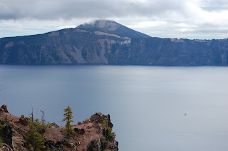
This park is young, established in 1986. It includes much of the South Snake Range. From sagebrush at it's base to Wheeler's Peak, 13,063 summit, there are lakes, streams, wildlife, varied forests and caves.

And - this is the best place to star gaze! They say they have the least amount of light pollution here in the U.S. Unfortunately, the moon is about 3/4 full.  We'll check during the night.
Mt. Wheeler - Great Basin NP
Aspen trees showing fall colors
Here's our back porch this evening
Mary's friend from the river
Oops - another toe shot, but man, this water is cold!
Sunset at Great Basin
The moon is rising

Creek behind our campsite at Great Basin

Friday, September 17, 2010

Day 22 - Trekking across Nevada

Brrrr.....44 degrees when we woke up this morning.  We thought we would make Great Basin National Park, but when I turned on the "lady in the box", she politely informed me that our destination was 598 miles away.  Ugh.......


If you've never been to Lakeview, OR and  you are in the neighborhood, check out the "Tallest Town in Oregon".  It has a very cute western facade, and a very nice laundromat.

The scenery in Nevada reminds us a lot of Big Bend country in Texas, except maybe not quite as dramatic.  While crossing the Sheldon National Wildlife Refuge, we did see a nice size herd of wild horses and a few ferral burros.  There were quite a few mountain passes - only 6000+ feet, but when they started, they pretty much went straight up.

I guess after 21 wonderful nights of campsites, it was time to finally reach one of "those"......you know, where they charge you an arm and a leg to park on crunchy gravel, 10' from your neighbor.  That's what we found at the Double Dice RV Park in Elko, Nevada.  Maybe if we were the gambling type of people, we would have found their casino a little interesting.   We do have cable TV, so guess we'll close the blinds and stay inside tonight.
Sheldon National Wildlife refuge
I think the sage brush is the state flower of Nevada.

Day 21 - Crater Lake National Park

So nice to wake up in the Oregon high desert!  Dry and cool with that fresh, semi-arid smell.

We got into the north entrance of Crater Lake and drove the west rim down.  It's really cold and windy up here - the truck says it is 43.  Cloudy and a few drizzles, so you can't really see the turquoise color like we did the last time we were here when it was surrounded by snow.

Crater Lake was the 6th national park established. It is 5 miles wide and ringed by cliffs almost 2,000' high.  The lake has a depth of 1,943 feet, the deepest in the United States.

We decided to keep driving and landed at Goose Lake State Park, right on the Oregon/California border.  (And Ron said he didn't want to go to California but I made him step on the state line!)  Lots of quail and deer. The neighbors had some sort of UFO thing they were flying in the dark. Sure glad we knew it really wasn't one because it sure appeared to be one.
Crater Lake
Crater Lake
CA on the left, OR on the right
And he said no going to CA!!
Crater Lake
Crater Lake
State Line sign from our bike ride
Deer don't know which state they like the best

Thursday, September 16, 2010

Day 20 - Happy Anniversary!

It's our 31st anniversary today!  What a way to celebrate!
  • Found some hot springs down the trail from our campsite - that was cool and unexpected.
  • Found one of the best views of Mount Ranier.
  • Stopped at a scenic overlook for Clear Springs Waterfall. It was the most beautiful waterfall we've see on the trip so far.
  • And then......in the distance at the head of the canyon, you could barely see an airplane. Then we noticed it was heading down the canyon. And then in the blink of an eye, the navy fighter jet (making an assumption since there is a navy base close by) buzzed us and rattled our insides and OMG - where are the ear plugs and then he tipped his wing at us and I do believe we saw the pilot in the cockpit, he was so close.  I tried my best to photograph it in motion, but heck....have you ever been buzzed by a plane like that?
  • Stopped for some groceries, asked the checker where was a good place to get a hamburger. She said the Conoco gas station.  And man.....was she right.  That was the best burger ever!
  • Passed a sign that told us we were half way between the North Pole and the Equator.
It was a good day! Enjoyed views of Mount Hood in the distance.  Landed at a state park in Oregon - The Cove Palisades.  It's on a lake in the Oregon high desert country.  Smells like fresh, desert air!
The plane in the distance that buzzed us
Clear Creek Waterfall
Mount Hood in the distance

Day 19 - Mount Ranier National Park

Mount Ranier

Said good-bye to the Pacific Ocean. We drove Highway 12 to the Stevens Canyon entrance. Found another awesome campsite on the Ohanapecosh River. Not only do we have another beautiful view off of the back porch, but the sound of the river rushing is pretty awesome too.  It's a good weather for Ranier.

The views of this mountain will take your breath away.  We did the short hike around Box Canyon.  The forest here is very dense, very green. There are tremendous snowfields that make you stand in awe - if you use the binoculars!
Back porch view - pretty awesome!
Mount Ranier
Mt. Ranier on the left, Box Canyon trail
The pearly everlasting is everywhere
Narada Falls
Mt. Ranier with a little sunset on it

Wednesday, September 15, 2010

Day 18 - The Pacific Coast

Ruby Beach
Left the rain forest for the beach!  Ruby Beach is just beautiful!  The ocean roars. The water is clear. The rocks are gray and black, flat and smooth. The sand is gray.  The water is cold!!!

Glenn and Marianne
The Lake Quinault area was beautiful, but it was still on the edge of the rain forest. We're ready to dry out!  Found an ideal spot at a state park called Pacific Beach.  We are on the beach.  (And of course sea fog rolls in right when we do.)  There are kites EVERYWHERE!!!  I couldn't wait to get on my bike and go to town and buy something to put on the camper to fly.  Found out they had a kite festival over the weekend.  It must be a big deal!  Anyway, we met this couple, Glenn and Mariann and they gave me a kite to fly, albeit teeny tiny. By the way, they won first place for their patriotic red, white and blue kites. But I could walk down the beach with it tied on to me and enjoy life. The fog lifted and we enjoyed a beautiful sunset over the Pacific.  And, the greatest part was that everything dried out.  Wish our Texas gulf coast beaches were this way!
Ruby Beach - Pacific
Remnants from the kite festival

Tuesday, September 14, 2010

Day 17 - The Hoh Rainforest, Olympic NP


It's cold and drizzly.  Glad our camper is an easy one to keep the floor clean!  Our first stop of the day was at Marymere Falls.  You walk through a tunnel under the highway to get there.  Pretty awesome!  The dampness really brings out the colors. You walk through beautiful lowland forest growth to the waterfalls.  Ferns everywhere!

We can go no further north or west now.  We're here. 

We make a stop at Rialto Beach. It is beautiful but it is fogged in. Because of the rain we skip the trails around it.  Decided it would be a good day to go hike in the rain forest so we head down the road to the Hoh Rainforest.  By the way, for all of you Twilight fans, we drive through Forks.  There are "Twilight" tour buses everywhere and vampire warnings.........

The Hoh rain forest is a temperate rain forest, where spruce and hemlock trees soar to heights of 200'. On our hike we saw big leaf maples that were so densely covered with mosses that they looked prehistoric. This area receives 140" on average of rainfall.  Found a perfect campsite at the Hoh campground.  Off our back porch about 30' is the Hoh River, roaring and splashing. And cold! We should be seeing elk normally, according to our neighbor, but guess it hasn't been cold enough for them to come down. Heck.

Have you ever cooked dinner in a rain forest with a rushing river right outside your window?  (I really do like my rear kitchen with the big window.  And the big awning on the back when it's dripping all around you.)

Mary at Marymere Falls
Lake Crescent
Marymere Falls hike
Rialto Beach
Rialto Beach, Olympic NP
Rialto Beach
Rain Forest Cedar
View from the back porch at Hoh Campground
It is a rain forest, what else would you expect?
Prehistoric......
Hoh Rain Forest
Nurse log in the rain forest