Our volunteer schedule involves us giving to the U.S. Fish
and Wildlife 24 hours each per week, so that’s working 3 days and off for
4. In exchange, we have a very nice full
hook-up site, located between a canal and Lake Mattamuskeet. It’s pretty quiet! Our new volunteer friends are very nice! As well as the employees here! Which is good.
 |
| This is where we sit by the canal to watch the deer and the sunsets. Beautiful! |
During our 4 days off, you’re going to find us out and about
exploring this great area. Last week we
decided to pull out the motorhome and head for the Outer Banks (OBX). The National Park Service has a campground,
Oregon Inlet, that has reservable 50 amp campsites. And we were able to snag one! Not a bad site, either! The beach was absolutely stunning, and the
weather was great. I even got a little
chilly!
 |
| Chilling! |
We had a couple of recommendations for eateries, and one of
them was O’Neal’s Sea Harvest. It’s a
down home type of place with a porch and retail fish store serving up seafood.
Pretty yummy!
 |
| Homemade tuna salad made with fresh caught tuna! Yummy! |
The next day we drove over to the Wright Brothers Memorial,
learning all about Wilbur and Orville Wright.
These brothers had a dream, which at the time was barely
respectable: the possibility of human
flight. They were both blessed with
intuitive mechanical ability along with analytical intelligence. Their work in aeronautics began seriously in
1899. They realized that so many great
minds in this field had made such little progress and they realized they had
just as good a chance as anyone else. And
the rest is history!

They learned to fly
on open sands near the Kill Devil Hills, located on the Outer Banks in North Carolina, where the site
provided isolation, high dunes, strong winds, and soft landings. In 1903 they mounted their own design
gasoline engine confidently onto a 17-foot glider. They went to Kitty Hawk
hoping to gain flying experience, but they flew the glider mostly as a
kite. Three days later, December 17,
1903, they try a second attempt and have 4 successful flights. There are
markers in the field commemorating these flights.
Our next day was spent driving down to Cape Hatteras to
check out the lighthouse there. What a
beauty! Did you know that this
lighthouse is America’s tallest at 208 feet?
And did you know that it was moved in 1999 to it’s present location due
to beach erosion? It was moved 2,900
feet in 23 days by professional house movers, of all things!
 |
| The Oregon Inlet is where most of your charter boats and tuna boats launch from. |
 |
| Cape Hatteras Lighthouse |
 |
| These next few pictures explain how they moved that big lighthouse. |
There is also another great museum, free, but donations are
encouraged. It’s called the Graveyard of
the Atlantic. Fascinating history here
as well!
Another recommended eatery was Fish Heads Bar &
Grill. If you ever decided to go there
if you’re in the area, try to get there before 4. Otherwise you’re sitting in
full sun or waiting for a table. They
had a happy hour and live music! Food
was decent, too.
 |
| Lots of coozies on the ceiling! |
The following week we rented a Bed and Breakfast,
War Hill Inn, out of Williamsburg, VA.
We had 2
things in mind –
Colonial National Historical Park, which is comprised of the
Historic Jamestown and Yorktown Battlefield.
And – since it’s been so blasted hot lately, we’ve been watching the
Food Network, more specifically
Guy Fieri’s “Diners, Drive-ins and Dives” and figured we
needed to go check one out in Virginia Beach.
It was a nice drive over, spotting a few bears along the way.
Lunch was awesome! The
name of the local joint was “Beach Pub.”
I enjoyed a rockfish reuben, while Ron enjoyed a soft crab sandwich.
 |
| Bear crossing the road |
 |
| Softshell crab sandwich |
 |
| Rockfish reuben |
 |
| Driving through Virginia Beach |
Our B&B was really great! Very typical of the Virginia architecture in
the area. We really enjoyed being out of
town, watching the black angus cattle, and sitting in rocking chairs on the front
porch.
Two of the most historically significant sites in English
North America are located in this area:
Jamestown, the first permanent English settlement in America, and the
Yorktown Battlefield, the final major battle of the American Revolution in
1781. The two parks are connected via
the Colonial Parkway, a 23-mile scenic byway, free of any modern commercial
development. It links Virginia’s Historic Triangle of Jamestown, Williamsburg
and Yorktown. Spectacular views of the
James and York Rivers, and turnouts along the Parkway off glimpses of the area’s
rich natural and cultural history.
Let’s talk about Jamestown first. This place is a national icon whose meaning
is entangled with the legend of Pocahontas and John Smith. It’s all here where we as Americans begin to
appreciate the true legacy of Virginia’s first capital when we understand it’s
role in English colonization, the growth of a representative government, and
the questions concerning African Americans, slavery, and American Indian
policies. These major themes of American
history had their beginnings at Jamestown.
 |
| Tercentenary Monument commemorates Jamestown's 300th anniversary. |
 |
| Statue of Pocahontas |
 |
| A drawing of the James Fort Site, 1607-1624 |
 |
| Capt. John Smith statue |
In 1607 vessels carrying 104 colonists anchor in the James
River on May 13. They establish the
colony of Virginia, with Jamestown as capital, allowing England to establish it’s
first permanent presence in North America.
By summer, colonists are dying from disease and starvation. The leadership of Capt. John Smith and help
from Powhatan tribes preserve the colony.
And when you walk this area, you wonder why they chose this spot? After all, it’s marshland. They thought they had found a passage through
to Asia. The day of our visit, we saw
many archeologists still working this area.
 |
| The Barracks |
 |
| Looking over the James River |
 |
| Cemetery |
 |
| So historical! |
 |
| This is on the huge cross |
 |
| Statehouse foundation |
In 1610, only 60 of nearly 300 colonists survive the “starving
time”. Archeologists have actually been
able to piece together that these colonists did partake of cannibalism to
survive. In 1619 America’s first representative
assembly in British North America met in the church at Jamestown. Africans also arrive, and a year later 90
unmarried women also arrive. And if you
don’t remember, their cash crop is tobacco.
There’s a lot of history here, too much to write about. If each American could come visit and learn
about the birth of our country here, I wonder if we would become a more united
country.
 |
| Pretty interesting stuff! |
In the late summer and early fall of 1781 soldiers gathered at
Yorktown to fight the last major battle of the American Revolution. Yorktown had been established in 1691 by an
Act for Ports passed by the Virginia House of Burgesses. By the early 17002 it was a major port town
serving Williamsburg, the new capital of Virginia. The Revolutionary War took it’s toll on Yorktown
and it never regained it’s economic prominence.
During the Civil War, Confederate and then Union forces held the town. Today it still functions as an active
community, though much smaller than during colonial times. The best way to understand the town is to do
a walking tour. There is a walkway from the Visitor Center to the town.
 |
| Yorktown National Cemetery (Confederate era) |
 |
| I found it interesting that the Civil War also used these same earthen structures. |
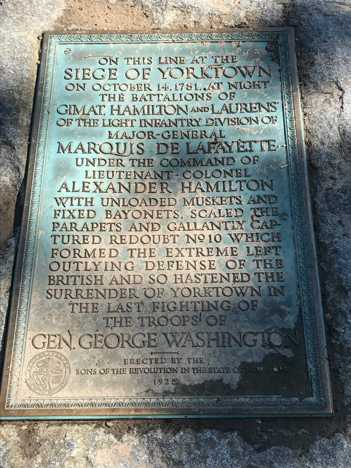
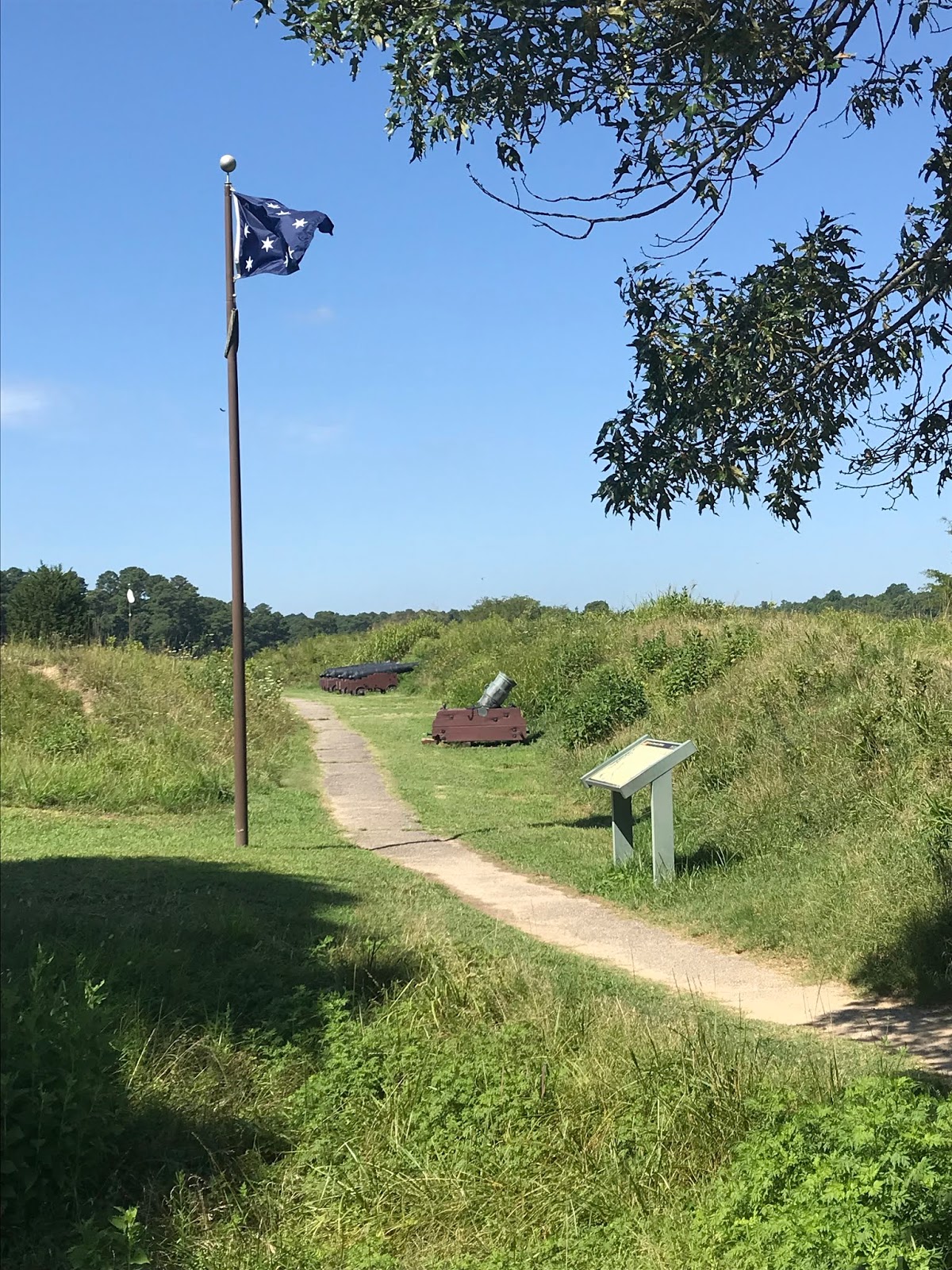
At the Yorktown Battlefield, you are able to view General
George Washington’s military tents and artifacts from the siege. They offer guided tours of the battle area
and 18th century Yorktown.
You are also able to drive the self-guided, seven mile battlefield tour
along American and French siege lines.
We stopped at the Moore House, site of surrender negotiations. For some people, you might get confused at
times as they also give a little history about Yorktown’s role in the Civil
War.
 |
| Do you see the distinctive dent from an allied cannonball? |
And yes, another history overload. Until next time!