Jeep

Jeep

Tuesday, May 8, 2012

Day 16 - May 7, 2012 - Crossing New Mexico

The thing about Arizona is they don't observe daylight savings time. So at 8:30 pm it is really dark and at 5:30 a.m. it is really bright. As we get ready to leave our campsite an eagle flies in and lands on a pine tree in front of us.  Oh wow! We don't get that experience too often.

To quote Capt. Ron....."I think we will just gut flop New Mexico today." Oh well, not a surprise to me.

Stopped for lunch in San Antonio, NM, at the Buckhorn Tavern.  You can read up on it, but their "green chili cheeseburger" is ranked #7 in America.  And man, it was awesome!

The weather is really strange today - very windy, tornado like winds, dust storms and some rain. We decided to land at Bottomless Lakes State Park outside of Roswell NM. Pretty place. Thundering like crazy. I grabbed the camera so I could get some pictures of the place before the rain hit.  Never figured that what I was going to see was some tornadoes forming. We alerted the camp hosts and located the bathrooms, in case we needed a safe place.  Those tornadoes went in another direction and we were feeling safe UNTIL we looked behind us and oh my gosh......there was one coming at us - you could see the debris and sticks and stuff blowing around it. The hail was starting and we didn't think we'd have time to make it to the closest bathroom.  I didn't know I could run that fast (at that altitude). Made it into the men's room with most of our fellow campers and waited it out. It went beside the campground, but that was still too close for me!  I appreciated observing several young folks on their knees praying for safety during it.  After all this excitement, things settled down enough to get out for a bike ride.  It did rain and thunder all night.  This area needed rain as they said it hasn't rained in 1 1/2 years here.

Look for the eagle!


Tornadoes kept forming here

This wasn't the one that came through the campground.


Sunday, May 6, 2012

Day 15 - May 6, 2012, Sunday - Fools Lake AZ

Took a short walk around a trail in the campground at Cat Tail and then off we go down I-40, which has to be one of the most horrible interstates there is, not to mention the 18-wheelers.  We ran parallel to a lot of the Historic Route 66. We exited the freeway at Winslow AZ (yes, you know that song) and headed towards one of the best ever state parks in any state.  It is called Fool Hollow Lake Recreation Area in Show Low, AZ. They were nice enough to park us in the site with the best view, which is #19.  This is a lake to bring your fishing poles and kayaks and stay and enjoy.  At the least, the next time you're heading west, stop here.

Get your kicks on Route 66! I remember driving this as a child.

View from our campsite at Fool Hollow.


Another beautiful sunset.

The scene from our backporch this evening.

Day 14 - Sat. May 5, 2012 - Lake Havasu AZ


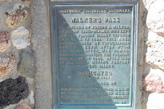
Stopped in town (Kernville) to look at their car show.  They were also having a town wide  garage sale, but we didn’t find any treasures to bring home.  Stopped at Walker’s Pass – makes me wonder if there is any ancestral bond to this trail blazer Joseph Walker.

Landed at Cat Tail Cove State Park on Lake Havasu.  Really nice campground and it did have electrical hookups.  Went for a swim in the lake and yes, the water was pretty cool, but the sun was pretty hot.

Met some new truck camper friends. Their license plate reads “2 COLD”.  Carol and Neil are from Carvel, Alberta, Canada. Eh?  Would have liked to have swapped more stories with them.

The full moon was big and bright coming over the mountains. 

I'm sure he is our long lost Walker relative


Ron and our Canadian neighbor

Beautiful sunset!


A view of Parker Dam

Saturday, May 5, 2012

Day 13 - May 4, 2012 - Kern River Area, CA

We start heading home today.  The thing about leaving this area is that there just isn't a straight route out.  So we'll head out by way of Visalia, then Bakersfield and go east towards Lake Isabella.

One of the memorable things we did today was to stop at a Supermarket in Visalia.  If you don't know the area we are in the middle of California's orchards and vineyards.  Well, this had to have been the most fun and colorful Mexican Supermarket ever!  I wish I would have had my camera.  The produce is pile high - several feet - and it is so neat and of course so fresh.  Many things I have not ever seen before.  The meat market was the same way and of course there was lots of stuff I did not know.  The deli was delicious smelling and the tortillas were being cranked out like crazy.  Ron struck up a conversation with the Miller Beer distributor who ended up tracking him down to give him a cap.

We stayed at the Camp James Campground in Kernville, recommended by the Chamber of Commerce lady.  A really nice park on the banks of the Kern River.  We have been lucky with the campgrounds.  Our neighbors own "Snow-Line Orchard" in Oak Glen CA.  They were very interesting.  They were here to buy antiques that they sell in their Apple Orchard.

Driving highway 178 from Bakersfield was challenging - a winding, narrow canyon highway.

The view from our back porch this evening!

Kern River


Thursday, May 3, 2012

Day 12 - May 3, 2012 - Sequoia National Park

Brr...it's cold up here!  Off to go driving down the General's Highway which connects Kings Canyon and Sequoia National Parks.  First stop was to visit the General Grant Tree.  Did you know that redwoods can live up to 2,000 years and Sequoias can live up to 3,200 years?  Also that this mountain range (Sierra Nevada) is the 2nd largest roadless area in the US? I bet the other is in Alaska!

Giant sequoias


This was actually used for camping once upon a time.


Gen. Grant tree

Overlooking the world's largest sequoia grove


Gen. Sherman Tree, world's largest living tree.
Our drive ended at the General Sherman tree, which is the world's largest living tree and is located in Sequoia NP. Had lots of snow at these upper elevations.  Too much hiking here sure leaves us breathless.


Day 11 - May 2, 2012 - Kings Canyon National Park

Had a great time in Yosemite but it's time to move on. Kings Canyon NP is south of Yosemite, maybe 150 miles.  Oh wow!  This place is beautiful! Higher elevations - 6000'. The Azalea Campground is super nice - bigger level spots. Undocked the camper and went driving through the park.  Not all the roads are open though.

Ran into a tour bus of French folks who were really impressed with Ron, the Texan, and his big Chevrolet dually truck.  They were taking lots of pictures!

It also seems that half to 2/3 of the people we are running into are from out of the country coming to see America's National Parks.


Humme Lake

This is how they stock the lake with trout


Beautiful canyon - Kings River


Bottom of the canyon - The Kings River


Beautiful white trees blooming everywhere


Sunset at the campground


Day 10 - May 1, 2012 - South Yosemite


Said good-bye to our camping neighbors, some of who were a family of Mennonites that are friends with those from El Campo.  It is a very pretty drive down to south Yosemite. After getting to the campground and not finding too level of sites, we decided we’d only stay the night.  We’re on the Merced River and it is nice and loud to hear. Took off to the Mariposa Grove of Giant Sequoias.  Only made the hike through the lower grove. This 6500’ of altitude helped us decide that we’d seen enough big, tall, red trees. J

Have to mention that we were camped by 3 elderly men – well into their 70’s. Figured there was a story there. They are 2 brothers and 1 friend who have been camping together here for over 60 years.  Their parents started them camping together.  Although they had a trailer, they set up 3 cots on the edge of the river and slept there.  They liked their martinis with 3 olives.  They also said that the park and this area are much prettier now than when they started coming here. Thanks to stricter conservation. (Makes me wish we had more controls in Texas for the Frio Valley as it sure isn’t what it was 40 years ago.)

Oh yes, we are now employed by Phillips 66! 

The most photographed spot in the entire USA. Can you imagine being the first to see it?

Mariposa Grove of giant Sequoias


Old Grizzly

The surviving tunnel tree

Wawona Hotel

Covered Bridge over the Merced River

Built around 1857